
Sale!
Original price was: $167.68.$96.99Current price is: $96.99.
- Multiple safe payment methods
- Fast and Secure Payments
- Superior Quality Goods
- Excellent customer service online in a timely manner

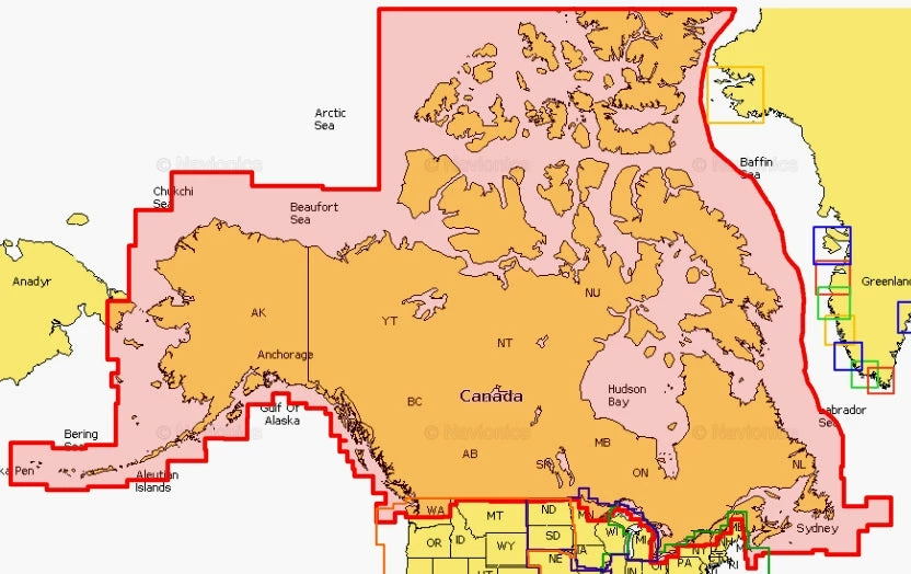
NAVIONICS PLUS NORTH AMERICA CHARTS
Features
– Up to 1’ contours – for a more accurate depiction of bottom structure
– Auto Guidance technology – calculates a suggested route
– Depth Range Shading – provides up to 10 depth ranges
– Shallow Water Shading – for a clear picture of shallow waters to avoid
| Navionics+ | Platinum+ | HotMaps Platinum | |
|---|---|---|---|
| Marine | • | • | |
| Lakes | • | • | |
| Nautical Chart | • | • | • |
| SonarChartTM | • | • | • |
| Community Edits | • | • | • |
| Daily Updates | • | • | • |
| Dock-to-dock Autorouting¹ | • | • | • |
| SonarChartTM Live | • | • | • |
| Advanced Map Options | • | • | • |
| Plotter Sync | • | • | • |
| Satellite Overlay with SonarChart Shading | • | • | |
| 3D View² | • | • | |
| Panoramic Photos | • | • |
Be the first to review “NAVIONICS PLUS CANADA CHARTS Electronics”
Related products
Sale!
Chartplotter Fishfinder
Original price was: $462.00.$92.99Current price is: $92.99.
Sale!
Original price was: $102.71.$82.17Current price is: $82.17.
Sale!
Electronics
Original price was: $274.38.$98.99Current price is: $98.99.
Sale!
Communication
Original price was: $168.51.$94.99Current price is: $94.99.
Sale!

Original price was: $221.03.$94.99Current price is: $94.99.
Sale!

Original price was: $182.92.$96.99Current price is: $96.99.
Sale!
Original price was: $550.00.$98.99Current price is: $98.99.
Sale!
Chartplotter Fishfinder
LOWRANCE HDS-9 LIVE NO TRANSDUCER REFURBISHED (Only 1 Left) Electronics
Original price was: $428.00.$93.99Current price is: $93.99.
Reviews
There are no reviews yet.